
The Places
Dallas County
Boynton Home
315 Lapsley Street
Selma, AL 36701
Brown Chapel A. M. E. Church
410 Martin Luther King Jr. Street
Selma, AL 36703
http://www.nps.gov/nr/travel/civilrights/al2.htm
Dallas County Courthouse
105 Lauderdale Street
Selma, AL
Dr. Sullivan and Mrs. Jean Jackson Home
416 Lapsley Street
Selma, AL 36701
Ebenezer Baptist Church
1548 Legrande Street
Selma, AL 36703
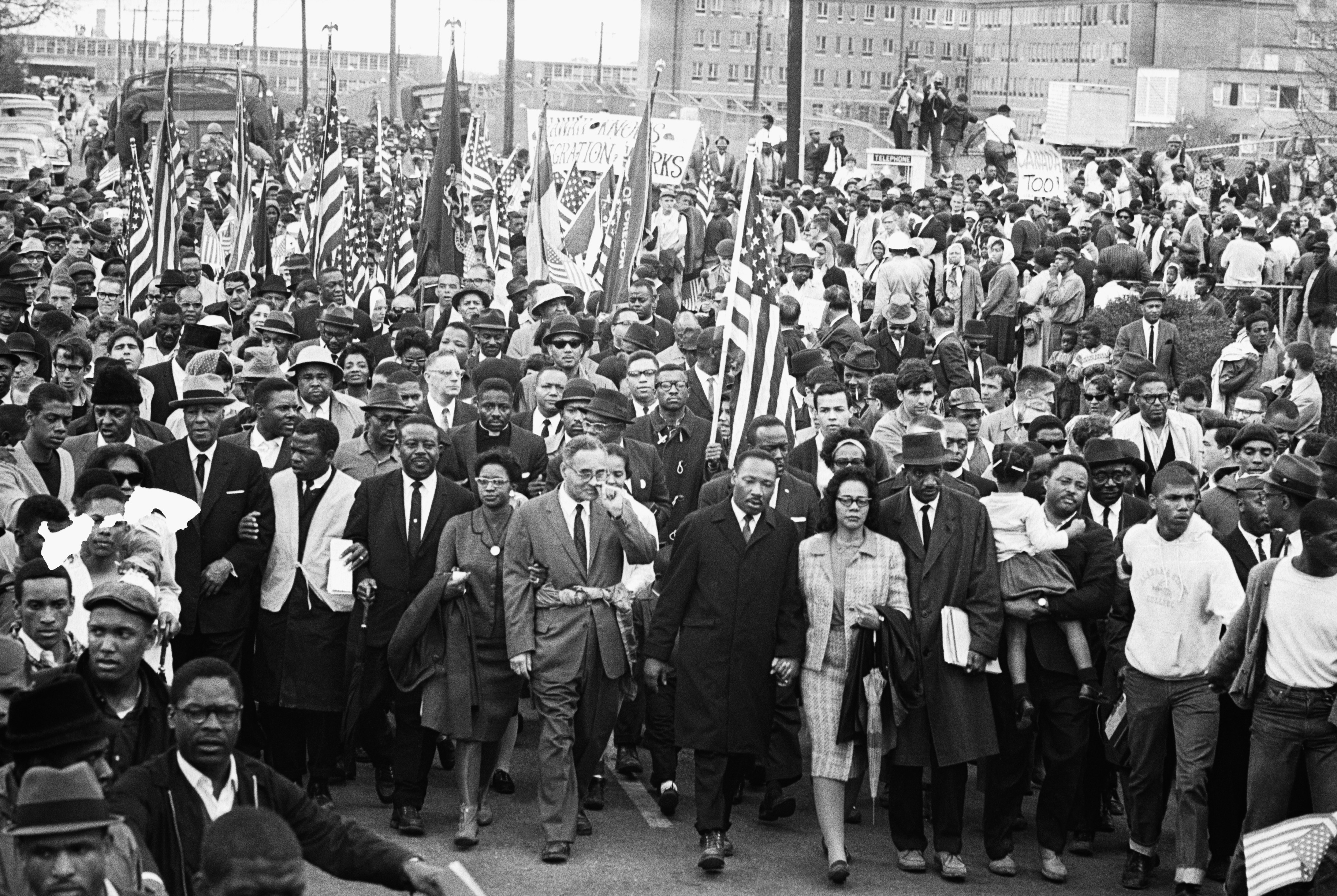
Edmund Pettus Bridge
U.S. Highway 80 across the Alabama River
Selma, AL
First Baptist Church
709 Martin Luther King Jr. Street
Selma, AL 36703
http://www.nps.gov/nr/travel/civilrights/al3.htm
Good Samaritan Hospital
Edmundite Missions
1428 Broad Street
Selma, AL 36701
http://www.edmunditemissions.org/history/civil-rights-history/
Martin Luther King, Jr. Street Historic Walking Tour
Martin Luther King, Jr. Street
Selma, AL 36701
http://www.selmaalabama.com/
Selma-to-Montgomery National Historic Trail
Selma Interpretive Center
2 Broad Street
Selma, AL 36701
http://www.nps.gov/semo/index.htm
Tabernacle Baptist Church
1431 Broad Street
Selma, AL 36701
Torch Motel (closed)
2nd Ave.
Selma, AL
Walker’s Café (closed)
118 Washington Street
Selma, AL 36703
Lowndes County
Lowndes Interpretive Center
7002 U.S. Hwy. 80 West
White Hall, AL 36040
http://www.nps.gov/semo/index.htm
Montgomery County
Alabama State Capitol
600 Dexter Ave.
Montgomery, AL 36104
(334) 242-3935
www.preserveala.org/capitoltour.htm
Alabama State University
915 South Jackson Street
Montgomery, AL 36104
http://www.lib.alasu.edu/natctr/index.html
Ben Moore Hotel
902 High Street
Montgomery, AL 36104
http://www.preservationnation.org/forum/african-american-historic-places/locations/southern/moore-ben-hotel.html
Beulah Baptist Church
3703 Rosa L. Parks Ave.
Montgomery, AL 36105
http://www.bbcmontg.org/
City of St. Jude
2048 W. Fairview Ave.
Montgomery, AL 36108
(334)265-6791
http://www.cityofstjude.org/campsite-4/
Dexter Avenue King Memorial Baptist Church
454 Dexter Ave.
Montgomery, AL 36104
http://www.dexterkingmemorial.org/
First Baptist Church
347 North Ripley Street
Montgomery, AL 36104
http://www.firstbaptistchurchmontgomery.com/
Frank M. Johnson, Jr. Federal Building and United States Courthouse
One Church Street
Montgomery, AL 36104
http://www.nps.gov/nr/travel/civilrights/al6.htm
Holt Street Memorial Baptist Church
1870 S. Court Street
Montgomery, Alabama 36104
Jackson Street Baptist Church
430 S. Jackson Street
Montgomery, Alabama 36104
Mt. Zion A.M.E. Zion Church
455 West Jeff Davis Avenue
Montgomery, Alabama 36104
http://www.mountzionamezion.org/
Driving Guide to the Historic Civil Rights Sites in Lowndes County, Alabama “The Dash Made the Difference
On Highway 80
Mt. Gillard Missionary Baptist Church
Address: 8376 Highway 80 West, Tyler, AL 36785
GPS Coordinates: 32.274540641557802/-86.74695516354404
Historic Significance: This church was the first in Lowndes County to permit mass meetings in support of the Civil Rights Movement. Established c. 1820, Mt. Gillard is recognized as the “Mother Church” for Civil Rights Leaders in the county.
Original Site of Tent City
Address: 7001 US Highway 80 West, White Hall, Hayneville, AL 36040
GPS Coordinates: 32.27026686358119/-86.72676080663223
Historic Significance: In 1965, white landowners evicted a significant number of black sharecropper families for attempting to or register to vote. Tents were elected as an emergency measure to house those evicted families.
Rosie Steele Farm Campsite
Address: 5892 US Highway 80 West, Hayneville, AL 36040
GPS Coordinates: 32.267919996843844/-86.70575374562759
Historic Significance: On March 22, 1965, the Voting Rights Marchers camped on the property located on US Highway 80 in White Hall. Mrs. Rosa Steele, an elderly widowed store owner, allowed marchers to stay on the land. As a result, she suffered many reprisals including a boycott of her store by vendors and distributors. It was the second campsite for the marchers.
Viola Liuzzo Memorial
Address: 2093 US Highway 80 East, Lowndesboro, AL 36040
GPS Coordinates: 32.26176678298309/-86.64370620847649
Historic Significance: Site of the murder of Mrs. Viola Liuzzo, a Detroit housewife, who assisted with the march by transporting marchers back to Selma from Montgomery.
Wright Chapel AME Zion Church
Address: 2093 US Highway 80, East, Lowndesboro, AL 36040
GPS Coordinates: 32.261766782298309/-86.64370620847649
Historic Significance: This church held mass meeting during the Civil Rights Movement. It is located next to the Viola Liuzzo Memorial statue.
Elmore Bolling Historic Site
Address: Intersection of US History 80 East and Abraham Road, Lowndesboro, AL 36040
GPS Coordinates: 32.26801902797184/-86.59019340266241
Historic Significance: Site of the lynching of thirty-nine year old Elmore Bolling, philanthropist and entrepreneur, whose inclusive trucking and transportation business ventures had begun to elevate the standards of living for black Lowndes County residents. This lynching on US Highway 80, now designated as both a National Historic Trail and a National Scenic/All American Road, occurred on a section that Elmore Bolling helped to build.
Robert Gardner Farm Campsite
Address: Intersection of US Highway 80, East and Frederick Douglass Road, Lowndesboro, AL 36752
GPS: Coordinates: 32.26901007927625/-86.43641500452067
Historic Significance: On March 23, 1965, the Voting Rights Marchers camped on the property of Mr. Robert Gardener, located on US Highway 80 and Frederick Douglass Road (formerly Caffey Road) in Burkeville, AL. This was the third campsite for the marchers.
Off Highway 80
Frank “Bud” Haralson Store
Address: 185 Freedom Road, Hayneville, AL 36040
GPS: Coordinates: 32.27261911113965/-86.72545993526
Historic Significance: This small country store was the place where the Lowndes County Christian Movement for Human Rights was organized in 1965.
Mt. Zion Church School
Address: 601 Freedom Road, Hayneville, AL 36040
GPS Coordinates: 32.29169995692649/-86.71728858549613
Historic Significance: This was one site where the country’s Freedom School was held. The school taught Black History, Citizenship Education, and Basic Remedial Skills. The Tuskegee Institute Community Education Program (TUCIP) conducted its enrichment programs for local youth here during the summer of 1965.
Student Non-Violent Coordinating Committee (SNCC) Freedom House
Address: 640 Freedom Road, Hayneville, AL 36040
GPS Coordinates: 32.29169995692649/-86.71728858549613
Historic Significance: Mr. Matthew Jackson, Sr. and family provided this property for the headquarters and home of the Lowndes County SNCC staff. Civil Rights activists stayed here when they came to the county to work.
Lowndes County Courthouse
Address: 1 Washington Street, Hayneville, AL 36040
GPS Coordinates: 32.1841119/-86.57994059999998
Historic Significance: The 1965 trials of Mr. Collie D. Williams, accused slayer of Viola Liuzzo, Detroit Civil Rights worker and Mr. Thomas “Tom” Coleman, an unpaid special deputy and accused murderer of Jonathan Daniels were held here. Founded in 1856, is one of only four antebellum courthouses still in use in Alabama.
Jonathan Daniel Memorial Site
Address: Corner of East Lafayette Street & South Commerce Street, Hayneville, AL 36040
GPS Coordinates: 32.18344485013243/-86.580663406473957
Historic Significance: A statue is erected in memory of Mr. Jonathan Daniels, who was a white seminary student from New Hampshire murdered after being released, along with other Civil Rights workers of SNCC and local youth, from the Lowndes County jail in August 1965.
First Missionary Baptist Church
Address: 361 Pine Street, Hayneville, AL 36040
GPS Coordinates: 32.1800105/-86.58578220000004
Historic Significance: At this church, in 196? the Lowndes County freedom Organization held its primary elections for candidates seeking political offices (Sheriff, School Board Members, Board of Revenue, Tax Collector, Tax Assessor and Coroner) under the Black Panther Party. It was the first time many blacks were able to exercise their right to vote.
Lowndes County Old Jail
Address: 35 Oak Street, Hayneville, AL 36040
GPS Coordinates: 32.181529412838/-86.58166129578603
Historic Significance: The jailhouse where Lowndes County blacks endured long lines, inclement weather, harassment, etc. while attempting to register to vote in 1965.
Jonathan Daniel Murder Site/Cash’s Store
Address: South Commerce Street, Hayneville, AL 36040
GPS Coordinates: 32.18140003184643/-86.58079231384363
Historic Significance: The small county store where Jonathan Daniels was murdered and Fr. Richard Morrisoe, a white Catholic priest, was shot and severely injured by Thomas “Tom” Coleman, an unpaid special deputy.
The Calhoun School
Address: 8213 County 33, Letohatchee, AL 36047
GPS Coordinates: 32.05812029677146/-86.55127959209494
Historic Significance: Founded in 1892, the school was the first for blacks in the county, which made available unprecedented educational opportunities. Calhoun provided crucial leadership to the Lowndes County Christian Movement for Human Rights, Lowndes County Freedom Organization and the subsequent election of blacks to political office.
Ramah Baptist Church
Address: 512 Calhoun Cutoff Road, Letohatchee, AL 36047
GPS Coordinates: 32.05154349012117/-86.55751873244298
Historic Significance: Founded in 1868, this church held many mass meetings during the Civil Rights Movement.
Macedonia Missionary Baptist Church
Address: 320 Golson Road, Ft. Deposit, AL 36047
GPS Coordinates: 31.97559979941715/-86.56915415514959
Historic Significance: This church held mass meetings during the Civil Rights Movement. Because it did, it was burned down. It was later rebuilt.